MONTEVIDEO PORT
|
|
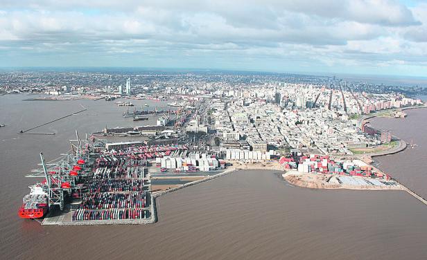
Description of PortMontevideo is the Capital of the República Oriental del Uruguay and has a population of about 1.500.000. The anteport is to the North of the entrance, between the breakwaters. The eastern breakwater projecting from Punta Sarandí is 940 m long and the western breakwater lying at right angles to the eastern one is 1300 m long. The passage between the two breakwaters is 300 m wide. The anchoring zone in the anteport requires dredging, and there is not room for more than five vessels. Where there are no buoys, it is usual to make a running moor. There are 4 mooring buoys in the anteport, to which vessels moor stern on to tranship cargo, F.G. reefer vessels receive frozen fish in transshipment here, with fishing vessels lying on either side of the on-carrying vessel.Scale PierThis berth, 288 m long, is orientated in a west to east direction at the head of the first quay that projects into the anteport. It is reserved for full container ships. The depth alongside is 30 ft at datum, The quay is fitted with a container gantry crane, maximum height 25 m, 40 ton SWL, operational rate 25 TEUS per hour. On the western side of this quay there is a paved open storage area of 70.000 sqm for handling containers and heavy lifts.River-traffic basin:This lies between the "Muelle fluvial" and Quay "A". It is almost triangular in shape, the entrance being 290 m wide; the West quay, 360 m long; the South 80 m; the East (on Quay "A") 383 metres. The west side of the basin is used by river traffic and has a passenger landing stage for ferryboats as well as two ramps for motor vehicles to roll on and off. The depth here is about 19,5 ft.Basin I:This lies between Quays "A" and "B". The passage between Quay "A" and the perpendicular breakwater from the "Dique de Cintura" is 150 meters wide. The shape of the Basin is rhomboidal; the West quay is 306 m long; the East 294 metres and the South 493 metres.Depths alongside are about 29 ft at datum, and about 31 ft when 5 metres off. Basin II:The western quay is 392 m long and the southern quay 394 m, forming an obtuse angle. On the western side of the basin there are 2 warehouses.Depths alongside abouth 28 ft datum (31 ft when 5 metres off) On the southern quay there is a cold store, having 3 chambers of abouth 8640 cbm each, total 26.000 cbm, apt for fruit, fish, meat, etc. The quay apron is 10 metres wide. Depth alongside 27 ft. Coastal quay wall:From the end of the southern quay of Basin II, the quay side continues for another 25 m and then sweeps round northwards for another 1650 m to breakwater "F". This area is used by coastal craft, and fishing vessels which discharge their catch to factories ashore.A floating dock is moored in the North-east part of this section. The depth here is between 16'4 and 13'1. "La Teja" Tanker berth:On the north side of the bay, the State Oil Company A.N.C.A.P., has a basin for the discharge of tankers arriving with oil to their consignment.This basin is known as the "Darsena de inflamables", and has one berth for tankers on the northern side with 28 ft at datum, and for liquid gas carriers on the southern side, maximum draft 22 ft FW, while on the western or land side there is a berth for coastal vessels, with a depth of about 12'. Width of the basin here is 147 m, which is the same as the entrance, whilst the southern berth is 248,75 m long. At the northern berth the jetty protrudes 34 metres, and is 96 m long. Vessels berth bow in, and on sailing turn inmediately outside the basin, on drafts of up to 22'. |